Home
All maps
Strelbickiy
RKKA
•
USSR
•
TopoMap
На
русском
All regional maps
Most popular
Thematic maps
Home
All maps
Most popular
Latitude:
Longitude:
Latitude:
Longitude:
Y
andex
+
G
oogle
+
O
ther
Small view
Additional map
Mark color:
Upload placemarks from a waypoint file:
Поддерживаются форматы
.wpt .pnt .gpx .kml
Максимальное число импортируемых точек: 5000
Save all placemarks to waypoint file:
Name ↔ Desc.
Double-click placemark to delete it.
Delete
all placemarks
You don't have any placemarks.
My placemarks
Go to the placemark's parent map / Placemark description
Go to
location
search everywhere
only on this map
Search Russian cities only.
Look at this place on the maps:
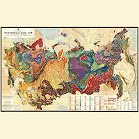
Geological map of Russia and the countries of the former USSR
1983
Multiple maps
One
Chronology
accurate:
Link to this place
Information about map
Date:
1983
Type:
Thematic map
Map size:
32400x23200 px
Country:
Russia and USSR
Regions:
Russia and USSR
Ukraine
Belarus
Kazakhstan
Coverage area:
From West to East: 1779.4 km From North to South: 6449.1 km Square: 11475341.6 km
2
Scale:
100 pixels represents:
5491 m
Download:
geologiya-1983.pdf
236.25
Mb
Related maps:
World map of volcanoes, earthquakes, and plate tectonics