Home
All maps
Strelbickiy
RKKA
•
USSR
•
TopoMap
На
русском
All regional maps
Most popular
Thematic maps
Home
All maps
Most popular
Latitude:
Longitude:
Latitude:
Longitude:
Y
andex
+
G
oogle
+
O
ther
Small view
Additional map
Mark color:
Upload placemarks from a waypoint file:
Поддерживаются форматы
.wpt .pnt .gpx .kml
Максимальное число импортируемых точек: 5000
Save all placemarks to waypoint file:
Name ↔ Desc.
Double-click placemark to delete it.
Delete
all placemarks
You don't have any placemarks.
My placemarks
Go to the placemark's parent map / Placemark description
Go to
location
search everywhere
only on this map
Search Russian cities only.
Look at this place on the maps:
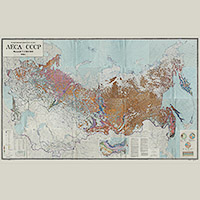
Map of the forests of Russia and the countries of the former USSR
1990
Multiple maps
One
Chronology
accurate:
Link to this place
Information about map
Date:
1990
Type:
Thematic map
Map size:
32400x23200 px
Country:
Russia and USSR
Regions:
Russia and USSR
Ukraine
Belarus
Kazakhstan
Coverage area:
From West to East: 1779.4 km From North to South: 6449.1 km Square: 11475341.6 km
2
Scale:
100 pixels represents:
5491 m
Download:
lesnaya-karta.pdf
143.60
Mb
Related maps:
Map of forests in Moscow region
Forest map of Moscow 2001
Map of the forests of the European part of the USSR in 1931
Map of the forests of the European part of the USSR, 1926