Home
All maps
History maps
Popular maps
Regional maps of Russia and countries of the former Soviet Union:
M
oscow
S
aint Petersburg
A
bakan
Anadyr
Arkhangelsk
Astrakhan
B
arnaul
Belgorod
Birobidzhan
Blagoveshchensk
Bryansk
C
heboksary
Chelyabinsk
Chita
E
lista
G
orno-Altaysk
I
rkutsk
Ivanovo
Izhevsk
K
aliningrad
Kaluga
Kazan
Kemerovo
Khabarovsk
Khanty-Mansiysk
Kirov
Kostroma
Krasnodar
Krasnoyarsk
Kurgan
Kursk
Kyzyl
L
ipetsk
M
agadan
Maykop
Murmansk
N
aryan-Mar
Nizhny Novgorod
Novosibirsk
O
msk
Orenburg
Oryol
P
enza
Perm
Petropavlovsk-Kamchatsky
Petrozavodsk
Pskov
R
ostov-on-Don
Ryazan
S
alekhard
Samara
Saransk
Saratov
Sevastopol
Simferopol
Smolensk
Stavropol
Syktyvkar
T
ambov
Tomsk
Tula
Tver
Tyumen
U
lan-Ude
Ufa
Ulyanovsk
V
eliky Novgorod
Vladimir
Vladivostok
Volgograd
Vologda
Voronezh
Y
akutsk
Yaroslavl
Yekaterinburg
Yoshkar-Ola
Yuzhno-Sakhalinsk
•
Belarus
Kazakhstan
Ukraine
Other countries
SORT BY:
New Arrivals
Oldest to Newest
Newest to Oldest
Most Popular
MAP TYPE:
All
City plans
Detailed
Overview
Thematic
History
Popular
Detailed maps of Kaliningrad region
Map fragment
Map name
Year
Region
-
Map type
Preview
47400 x 22400 Views per day:
140
Accuracy:
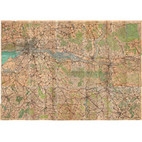
German map of East Prussia 1934
1934
Kaliningrad region - detailed map
9400 x 6400 Views per day:
10
Accuracy:
German map of Pillau (Baltiysk) 1942
1940
-
1944
Kaliningrad region - detailed map
6400 x 7800 Views per day:
3
Accuracy:
Map of Baltiysk 1984
1984
Kaliningrad region - detailed map
49000 x 22400 Views per day:
30
Accuracy:
German map of East Prussia 1944
1944
Kaliningrad region - detailed map
46000 x 41200 Views per day:
10
Accuracy:
Atlas of central Europe 1838 by J.E. Woerl
1838
World - detailed map
8200 x 8400 Views per day:
10
Accuracy:
Map of Konigsberg with forts and inter-forts
1944
Kaliningrad region - detailed map
8200 x 7000 Views per day:
10
Accuracy:
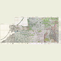
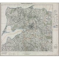
Map of surroundings of Königsberg in 1934
1934
Kaliningrad region - detailed map
8200 x 7000 Views per day:
10
Accuracy:
Map of surroundings of Königsberg in 1928
1928
Kaliningrad region - detailed map
15000 x 10600 Views per day:
10
Accuracy:
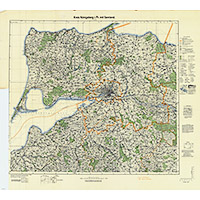
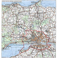
Topographic map of the center of the Kaliningrad region, 1958
1958
Kaliningrad region - detailed map
35400 x 40200 Views per day:
60
Accuracy:
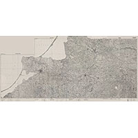
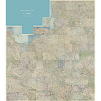
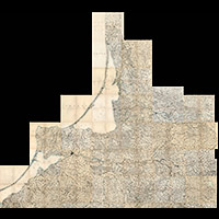
Map of the Kaliningrad region (East Prussia) and the north of Poland of the General Staff of the Red Army N-34
1932
-
1943
Kaliningrad region - detailed map
2000 x 2000 Views per day:
5
Accuracy:
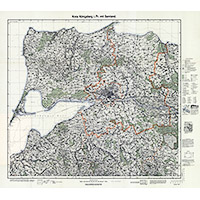
Topographic map of the center of the Kaliningrad region, 1997
1997
Kaliningrad region - detailed map
5200 x 4200 Views per day:
5
Accuracy:
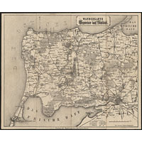
Map of the surroundings of Koenigsberg in 1894
1894
Kaliningrad region - detailed map
100800 x 83600 Views per day:
30
Accuracy:
Map of the German Reich 1:100000, 1878-1904
1878
-
1904
World - detailed map
7600 x 7000 Views per day:
20
Accuracy:
Map of surroundings of Königsberg in 1938
1938
Kaliningrad region - detailed map
5400 x 2600 Views per day:
1
Accuracy:
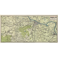
Pharus-plan of Tilsit suburbs, 1928
1928
Kaliningrad region - detailed map
NEXT
1
2
3
4
5
>>>