Home
All maps
History maps
Popular maps
Regional maps of Russia and countries of the former Soviet Union:
M
oscow
S
aint Petersburg
A
bakan
Anadyr
Arkhangelsk
Astrakhan
B
arnaul
Belgorod
Birobidzhan
Blagoveshchensk
Bryansk
C
heboksary
Chelyabinsk
Chita
E
lista
G
orno-Altaysk
I
rkutsk
Ivanovo
Izhevsk
K
aliningrad
Kaluga
Kazan
Kemerovo
Khabarovsk
Khanty-Mansiysk
Kirov
Kostroma
Krasnodar
Krasnoyarsk
Kurgan
Kursk
Kyzyl
L
ipetsk
M
agadan
Maykop
Murmansk
N
aryan-Mar
Nizhny Novgorod
Novosibirsk
O
msk
Orenburg
Oryol
P
enza
Perm
Petropavlovsk-Kamchatsky
Petrozavodsk
Pskov
R
ostov-on-Don
Ryazan
S
alekhard
Samara
Saransk
Saratov
Sevastopol
Simferopol
Smolensk
Stavropol
Syktyvkar
T
ambov
Tomsk
Tula
Tver
Tyumen
U
lan-Ude
Ufa
Ulyanovsk
V
eliky Novgorod
Vladimir
Vladivostok
Volgograd
Vologda
Voronezh
Y
akutsk
Yaroslavl
Yekaterinburg
Yoshkar-Ola
Yuzhno-Sakhalinsk
•
Belarus
Kazakhstan
Ukraine
Other countries
SORT BY:
New Arrivals
Oldest to Newest
Newest to Oldest
Most Popular
MAP TYPE:
All
City plans
Detailed
Overview
Thematic
History
Popular
Online historical maps of Rostov region
Map fragment
Map name
Year
Region
-
Map type
Preview
4600 x 3400 Views per day:
5
Accuracy:
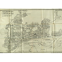
Schematic plan of the city of Rostov-on-Don
1936
Rostov-on-Don - city plan
7000 x 7000 Views per day:
20
Accuracy:
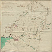
Map of the Don Cossacks in 1782
1782
Rostov region - overview map
1800 x 1400 Views per day:
2
Accuracy:
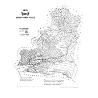
Scheme of population displacement during the construction of the Tsimlyansk reservoir
1953
Thematic map of Rostov region
13400 x 9600 Views per day:
6
Accuracy:
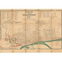
Plan of the cities of Rostov and Nakhichevan on the Don, 1924
1924
Rostov-on-Don - city plan
5600 x 6000 Views per day:
7
Accuracy:
Administrative map of the Rostov region 1978
1978
Rostov region - overview map
10600 x 11200 Views per day:
10
Accuracy:
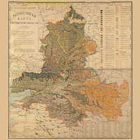
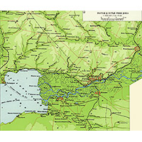
Soil map of the Rostov region in 1939
1939
Rostov region - detailed map
3000 x 3600 Views per day:
10
Accuracy:
Map of the Volosts of the Don Cossack Region
1890
Rostov region - overview map
5600 x 5600 Views per day:
30
Accuracy:
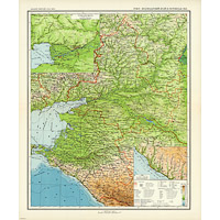
Map of the North Caucasus Territory 1929
1929
Kuban and Caucasus - overview map
12000 x 9600 Views per day:
7
Accuracy:
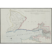
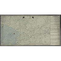
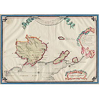
General map of the Taganrog City Administration
1816
Rostov region - detailed map
8000 x 9000 Views per day:
20
Accuracy:
Krasnodar territory and Rostov region - BSAM
1939
Kuban and Caucasus - overview map
2000 x 1800 Views per day:
3
Accuracy:
Rostov and the mouth of the Don River - BSAM
1939
Rostov region - detailed map
5000 x 5000 Views per day:
9
Accuracy:
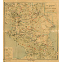
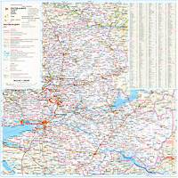
Road map of the Rostov region 2004
2004
Rostov region - overview map
19400 x 10400 Views per day:
7
Accuracy:
Lower Don Map of 1748
1748
Rostov region - detailed map
8800 x 7000 Views per day:
8
Accuracy:
General plan of the Mariupol district of 1784
1784
Detailed map
3200 x 2600 Views per day:
8
Accuracy:
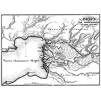
Azov and its surroundings at the end of the 17th century
1695
Rostov region - detailed map
BACK
NEXT
1
2
3
4
5
6
7
>>>