Home
All maps
History maps
Popular maps
Regional maps of Russia and countries of the former Soviet Union:
M
oscow
S
aint Petersburg
A
bakan
Anadyr
Arkhangelsk
Astrakhan
B
arnaul
Belgorod
Birobidzhan
Blagoveshchensk
Bryansk
C
heboksary
Chelyabinsk
Chita
E
lista
G
orno-Altaysk
I
rkutsk
Ivanovo
Izhevsk
K
aliningrad
Kaluga
Kazan
Kemerovo
Khabarovsk
Khanty-Mansiysk
Kirov
Kostroma
Krasnodar
Krasnoyarsk
Kurgan
Kursk
Kyzyl
L
ipetsk
M
agadan
Maykop
Murmansk
N
aryan-Mar
Nizhny Novgorod
Novosibirsk
O
msk
Orenburg
Oryol
P
enza
Perm
Petropavlovsk-Kamchatsky
Petrozavodsk
Pskov
R
ostov-on-Don
Ryazan
S
alekhard
Samara
Saransk
Saratov
Sevastopol
Simferopol
Smolensk
Stavropol
Syktyvkar
T
ambov
Tomsk
Tula
Tver
Tyumen
U
lan-Ude
Ufa
Ulyanovsk
V
eliky Novgorod
Vladimir
Vladivostok
Volgograd
Vologda
Voronezh
Y
akutsk
Yaroslavl
Yekaterinburg
Yoshkar-Ola
Yuzhno-Sakhalinsk
•
Belarus
Kazakhstan
Ukraine
Other countries
Online historical maps of Russia and the USSR
Map fragment
Map name
Year
Region
-
Map type
Preview
11600 x 7600 Views per day:
6
Accuracy:
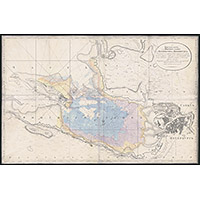
The first flat map of the Gulf of Finland in 1808
1808
World - detailed map
6000 x 5200 Views per day:
1
Accuracy:
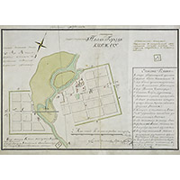
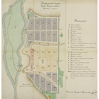
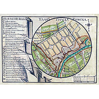
The projected plan of the city of Kirzhach of the first half of the XIX century
1810
Map of Kirzhach
6800 x 3800 Views per day:
3
Accuracy:
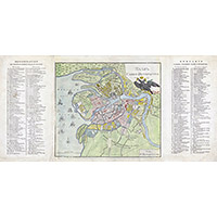
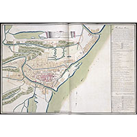
Plan of St. Petersburg 1810 in French and Russian
1810
Saint Petersburg - city plan
7800 x 5200 Views per day:
3
Accuracy:
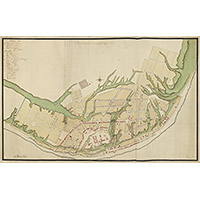
Project plan of the provincial city of Nizhny Novgorod at the beginning of the 19th century
1810
Nizhny Novgorod - city plan
4400 x 4600 Views per day:
3
Accuracy:
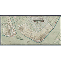
General plan of the city of Borisoglebsk, Tambov province
1810
Map of Borisoglebsk
10600 x 9800 Views per day:
1
Accuracy:
Plan of the district town of Pereslavl-Zalessky, 1808
1808
Yaroslavl region - detailed map
8000 x 5600 Views per day:
10
Accuracy:
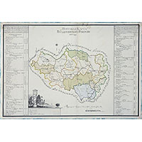
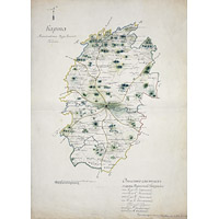
Postal map of Vladimir province, 1809
1809
Vladimir region - overview map
7600 x 6400 Views per day:
7
Accuracy:
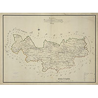
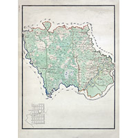
Map of Aleksandrovsky district of Vladimir province, 1808
1808
Vladimir region - detailed map
9800 x 6600 Views per day:
10
Accuracy:
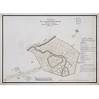
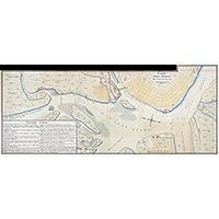
Plan of the provincial city of Astrakhan in 1810
1810
Astrakhan - city plan
4400 x 5800 Views per day:
6
Accuracy:
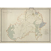
Map of Mikhailovsky district in 1810
1810
Ryazan region - detailed map
5600 x 7400 Views per day:
5
Accuracy:
Map of the Melenki areat in 1810
1810
Vladimir region - detailed map
7200 x 5400 Views per day:
5
Accuracy:
Map of Tsarskoye Selo district in 1808
1808
Leningrad region - detailed map
7600 x 13600 Views per day:
7
Accuracy:
Plan of the provincial city of Arkhangelsk in 1809
1809
Arkhangelsk - city plan
9800 x 15800 Views per day:
1
Accuracy:
Plan of the city of Arkhangelsk with harbors in 1810
1810
Arkhangelsk - city plan
2600 x 2000 Views per day:
0
Accuracy:
City plan of Ryazhsk 1809
1809
Map of Ryazhsk
NEXT