Home
All maps
History maps
Popular maps
Regional maps of Russia and countries of the former Soviet Union:
M
oscow
S
aint Petersburg
A
bakan
Anadyr
Arkhangelsk
Astrakhan
B
arnaul
Belgorod
Birobidzhan
Blagoveshchensk
Bryansk
C
heboksary
Chelyabinsk
Chita
E
lista
G
orno-Altaysk
I
rkutsk
Ivanovo
Izhevsk
K
aliningrad
Kaluga
Kazan
Kemerovo
Khabarovsk
Khanty-Mansiysk
Kirov
Kostroma
Krasnodar
Krasnoyarsk
Kurgan
Kursk
Kyzyl
L
ipetsk
M
agadan
Maykop
Murmansk
N
aryan-Mar
Nizhny Novgorod
Novosibirsk
O
msk
Orenburg
Oryol
P
enza
Perm
Petropavlovsk-Kamchatsky
Petrozavodsk
Pskov
R
ostov-on-Don
Ryazan
S
alekhard
Samara
Saransk
Saratov
Sevastopol
Simferopol
Smolensk
Stavropol
Syktyvkar
T
ambov
Tomsk
Tula
Tver
Tyumen
U
lan-Ude
Ufa
Ulyanovsk
V
eliky Novgorod
Vladimir
Vladivostok
Volgograd
Vologda
Voronezh
Y
akutsk
Yaroslavl
Yekaterinburg
Yoshkar-Ola
Yuzhno-Sakhalinsk
•
Belarus
Kazakhstan
Ukraine
Other countries
Online historical maps of Russia and the USSR
Map fragment
Map name
Year
Region
-
Map type
Preview
5400 x 7200 Views per day:
5
Accuracy:
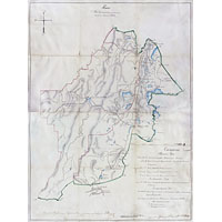
Plan of the dachas of the Zlatoust and Miass mining plants, 1859
1859
Chelyabinsk region - detailed map
11600 x 12200 Views per day:
2
Accuracy:
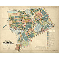
Plan of the city of Pavlovsk in 1859 by Major Blaramberg
1859
Map of Pavlovsk
6800 x 6200 Views per day:
2
Accuracy:
Plan of the settlement of Dubovka, Tsaritsyn district, 1859
1859
Volgograd region - detailed map
13800 x 21000 Views per day:
3
Accuracy:
Plan of the district town of Pereslavl-Zalessky, 1858
1858
Yaroslavl region - detailed map
9200 x 6800 Views per day:
0
Accuracy:
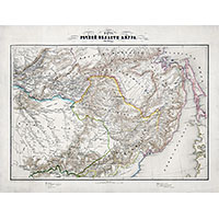
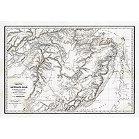
Map of the Amur River region, 1859
1859
Amur region - overview map
9200 x 7400 Views per day:
3
Accuracy:
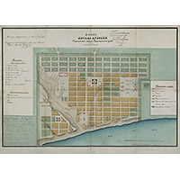
Plan of the district town of Alexandrov, 1858
1858
Map of Aleksandrov
5000 x 5600 Views per day:
4
Accuracy:
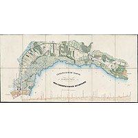
Map of the surrounding areas of Krasnoe Selo, Pulkovo and Strelna 1858
1858
Leningrad region - detailed map
4400 x 4000 Views per day:
1
Accuracy:
Map of the surrounding area of Kharkov in 1859
1859
Detailed map
4000 x 5000 Views per day:
9
Accuracy:
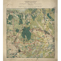
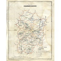
Map of the Ryazan province in 1859
1859
Ryazan region - overview map
17600 x 11400 Views per day:
3
Accuracy:
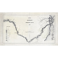
Map of the Amur Waterway 1857
1857
Amur region - overview map
6600 x 4600 Views per day:
4
Accuracy:
Map of the Amur region in 1859
1859
Amur region - overview map
9800 x 11000 Views per day:
2
Accuracy:
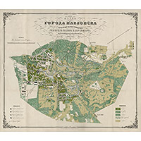
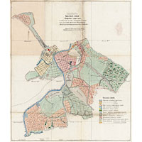
Plan of pasture lands of the city of Orel for 1859
1859
Oryol - city plan
9600 x 9400 Views per day:
1
Accuracy:
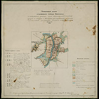
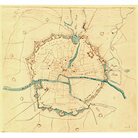
Boundary plan of the provincial city of Vitebsk in 1858
1858
Map of Vitebsk
12000 x 6000 Views per day:
2
Accuracy:
Map of the railway from St. Petersburg to Peterhof
1857
Leningrad region - detailed map
4800 x 4400 Views per day:
5
Accuracy:
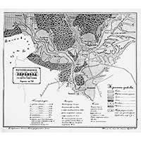
Königsberg defensive structure plan of 1859
1859
Kaliningrad - city plan
NEXT