Home
All maps
History maps
Popular maps
Regional maps of Russia and countries of the former Soviet Union:
M
oscow
S
aint Petersburg
A
bakan
Anadyr
Arkhangelsk
Astrakhan
B
arnaul
Belgorod
Birobidzhan
Blagoveshchensk
Bryansk
C
heboksary
Chelyabinsk
Chita
E
lista
G
orno-Altaysk
I
rkutsk
Ivanovo
Izhevsk
K
aliningrad
Kaluga
Kazan
Kemerovo
Khabarovsk
Khanty-Mansiysk
Kirov
Kostroma
Krasnodar
Krasnoyarsk
Kurgan
Kursk
Kyzyl
L
ipetsk
M
agadan
Maykop
Murmansk
N
aryan-Mar
Nizhny Novgorod
Novosibirsk
O
msk
Orenburg
Oryol
P
enza
Perm
Petropavlovsk-Kamchatsky
Petrozavodsk
Pskov
R
ostov-on-Don
Ryazan
S
alekhard
Samara
Saransk
Saratov
Sevastopol
Simferopol
Smolensk
Stavropol
Syktyvkar
T
ambov
Tomsk
Tula
Tver
Tyumen
U
lan-Ude
Ufa
Ulyanovsk
V
eliky Novgorod
Vladimir
Vladivostok
Volgograd
Vologda
Voronezh
Y
akutsk
Yaroslavl
Yekaterinburg
Yoshkar-Ola
Yuzhno-Sakhalinsk
•
Belarus
Kazakhstan
Ukraine
Other countries
Online historical maps of Russia and the USSR
Map fragment
Map name
Year
Region
-
Map type
Preview
14400 x 11400 Views per day:
3
Accuracy:
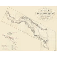
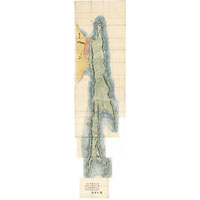
Atlas of the mouth of the Amur River, 1864
1864
Khabarovsk territory - detailed map
12400 x 11800 Views per day:
10
Accuracy:
Map of the southwest of Ustyuzhensky district in 1863
1863
-
1865
Novgorod region - detailed map
5000 x 6000 Views per day:
5
Accuracy:
Map of Ust-Sysolsky district in 1864
1864
Komi Republic - overview map
2600 x 3400 Views per day:
1
Accuracy:
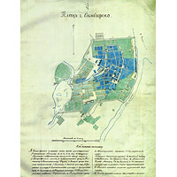
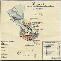
Plan of the city of Simbirsk in 1864 after the fire
1864
Ulyanovsk - city plan
5600 x 6600 Views per day:
2
Accuracy:
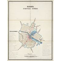
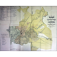
General plan of the city of Orenburg 1864
1864
Orenburg - city plan
4400 x 5400 Views per day:
2
Accuracy:
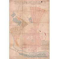
Tula city plan 1865
1865
Tula - city plan
17600 x 14600 Views per day:
0
Accuracy:
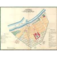
Plan of the city of Chistopol, Kazan province, 1865
1865
Map of Chistopol
23800 x 21600 Views per day:
20
Accuracy:
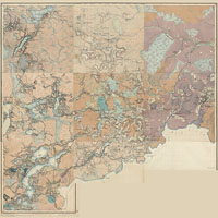
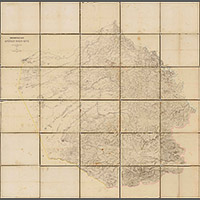
Map of the Altai mountain district in 1864
1864
-
1868
Altai territory - detailed map
3600 x 3600 Views per day:
1
Accuracy:
Plan of the district town of Volokolamsk in 1864 with pasture lands
1864
Map of Volokolamsk
4400 x 3400 Views per day:
1
Accuracy:
Plan of the provincial city of Kharkov 1866
1866
City plan
9600 x 6400 Views per day:
1
Accuracy:
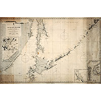
Map of the Kuril Islands 1865
1865
Sakhalin region - overview map
3800 x 12600 Views per day:
1
Accuracy:
Complete Japanese map of Sakhalin 1865
1865
Sakhalin region - overview map
3200 x 2400 Views per day:
1
Accuracy:
Plan of the city of Belozersk in 1865
1865
Map of Belozersk
12400 x 12600 Views per day:
30
Accuracy:
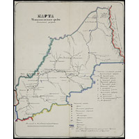
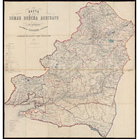
Map of the Land of the Don Cossacks in 1865
1865
Rostov region - detailed map
24200 x 19600 Views per day:
8
Accuracy:
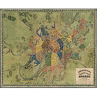
General plan of Moscow in 1864
1864
-
1874
Moscow - city plan
NEXT