Home
All maps
History maps
Popular maps
Regional maps of Russia and countries of the former Soviet Union:
M
oscow
S
aint Petersburg
A
bakan
Anadyr
Arkhangelsk
Astrakhan
B
arnaul
Belgorod
Birobidzhan
Blagoveshchensk
Bryansk
C
heboksary
Chelyabinsk
Chita
E
lista
G
orno-Altaysk
I
rkutsk
Ivanovo
Izhevsk
K
aliningrad
Kaluga
Kazan
Kemerovo
Khabarovsk
Khanty-Mansiysk
Kirov
Kostroma
Krasnodar
Krasnoyarsk
Kurgan
Kursk
Kyzyl
L
ipetsk
M
agadan
Maykop
Murmansk
N
aryan-Mar
Nizhny Novgorod
Novosibirsk
O
msk
Orenburg
Oryol
P
enza
Perm
Petropavlovsk-Kamchatsky
Petrozavodsk
Pskov
R
ostov-on-Don
Ryazan
S
alekhard
Samara
Saransk
Saratov
Sevastopol
Simferopol
Smolensk
Stavropol
Syktyvkar
T
ambov
Tomsk
Tula
Tver
Tyumen
U
lan-Ude
Ufa
Ulyanovsk
V
eliky Novgorod
Vladimir
Vladivostok
Volgograd
Vologda
Voronezh
Y
akutsk
Yaroslavl
Yekaterinburg
Yoshkar-Ola
Yuzhno-Sakhalinsk
•
Belarus
Kazakhstan
Ukraine
Other countries
Online historical maps of Russia and the USSR
Map fragment
Map name
Year
Region
-
Map type
Preview
5000 x 4600 Views per day:
2
Accuracy:
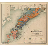
Map of the Muravyov-Amursky Peninsula 1912
1912
Primorye territory - detailed map
6200 x 5400 Views per day:
1
Accuracy:
City plan of Yekaterinoslav 1912
1912
City plan
10800 x 10400 Views per day:
2
Accuracy:
Armavir plan of 1912
1912
Kuban and Caucasus - detailed map
35400 x 24400 Views per day:
6
Accuracy:
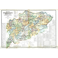
Map of the Trans-Baikal Region, 1912
1912
Trans-Baikal territory - detailed map
10200 x 7200 Views per day:
10
Accuracy:
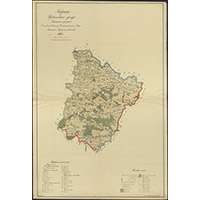
Map of the Menzelinsk district of the Ufa province 1912
1911
-
1912
Republic of Tatarstan - detailed map
2600 x 2800 Views per day:
1
Accuracy:
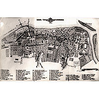
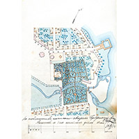
General plan of Cathedral Square and the Public Garden of Petrozavodsk
1912
Petrozavodsk - city plan
13000 x 16200 Views per day:
10
Accuracy:
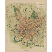
Plan of Moscow from the cartographic institutions Ilyin, 1912
1912
Moscow - city plan
12000 x 12600 Views per day:
4
Accuracy:
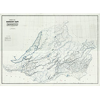
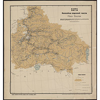
Map of the basin of the upper part of the Yenisei River, 1912
1912
Krasnoyarsk territory - overview map
5800 x 8200 Views per day:
3
Accuracy:
Map of the Civilsk district, 1912
1912
Chuvash Republic - detailed map
6200 x 5400 Views per day:
6
Accuracy:
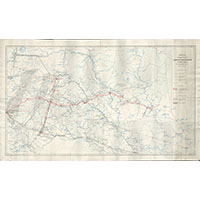
Plan of the North-East-Ural Railway in 1912
1912
Sverdlovsk region - overview map
2200 x 1600 Views per day:
2
Accuracy:
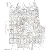
Plan of the Powder Town of Kazan in 1912
1912
Kazan - city plan
8400 x 6600 Views per day:
9
Accuracy:
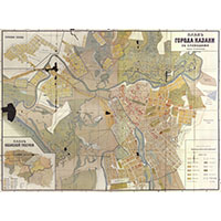
Plan of the city of Kazan, 1912
1912
Kazan - city plan
2000 x 2000 Views per day:
3
Accuracy:
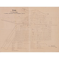
Plan of the city of Petrozavodsk
1887
-
1912
Petrozavodsk - city plan
7200 x 5200 Views per day:
5
Accuracy:
Map of the boundaries of forest areas of Kostroma province in 1912
1912
Kostroma region - overview map
2200 x 2600 Views per day:
2
Accuracy:
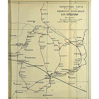
Route map of Ishim expedition by B. Gorodkov
1912
Tyumen region - overview map
NEXT