Home
All maps
History maps
Popular maps
Regional maps of Russia and countries of the former Soviet Union:
M
oscow
S
aint Petersburg
A
bakan
Anadyr
Arkhangelsk
Astrakhan
B
arnaul
Belgorod
Birobidzhan
Blagoveshchensk
Bryansk
C
heboksary
Chelyabinsk
Chita
E
lista
G
orno-Altaysk
I
rkutsk
Ivanovo
Izhevsk
K
aliningrad
Kaluga
Kazan
Kemerovo
Khabarovsk
Khanty-Mansiysk
Kirov
Kostroma
Krasnodar
Krasnoyarsk
Kurgan
Kursk
Kyzyl
L
ipetsk
M
agadan
Maykop
Murmansk
N
aryan-Mar
Nizhny Novgorod
Novosibirsk
O
msk
Orenburg
Oryol
P
enza
Perm
Petropavlovsk-Kamchatsky
Petrozavodsk
Pskov
R
ostov-on-Don
Ryazan
S
alekhard
Samara
Saransk
Saratov
Sevastopol
Simferopol
Smolensk
Stavropol
Syktyvkar
T
ambov
Tomsk
Tula
Tver
Tyumen
U
lan-Ude
Ufa
Ulyanovsk
V
eliky Novgorod
Vladimir
Vladivostok
Volgograd
Vologda
Voronezh
Y
akutsk
Yaroslavl
Yekaterinburg
Yoshkar-Ola
Yuzhno-Sakhalinsk
•
Belarus
Kazakhstan
Ukraine
Other countries
Online historical maps of Russia and the USSR
Map fragment
Map name
Year
Region
-
Map type
Preview
8000 x 5400 Views per day:
8
Accuracy:
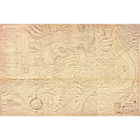
General plan of the center of Ukhta, 1950
1950
Komi Republic - detailed map
9000 x 8000 Views per day:
5
Accuracy:
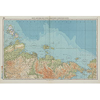
Map of the Laptev, East Siberian and Chukchi seas from the Marine Atlas
1950
Russia and USSR - overview map
12000 x 8200 Views per day:
30
Accuracy:
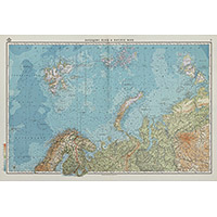
Map of the Barents, White and Kara Seas from the Marine Atlas
1950
Russia and USSR - overview map
10000 x 6800 Views per day:
6
Accuracy:
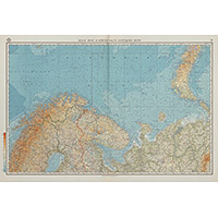
Map of the White Sea from the Marine Atlas
1950
Russia and USSR - overview map
9000 x 13200 Views per day:
5
Accuracy:
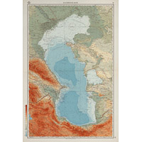
Map of the Caspian Sea from the Marine Atlas
1950
Russia and USSR - overview map
8200 x 5600 Views per day:
40
Accuracy:
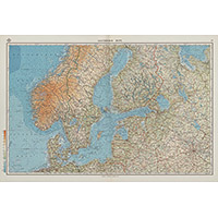
Map of the Baltic Sea from the Marine Atlas
1950
World - overview map
8800 x 13000 Views per day:
5
Accuracy:
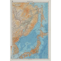
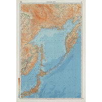
Map of the Sea of Japan from the Marine Atlas
1950
Russia and USSR - overview map
13600 x 9400 Views per day:
20
Accuracy:
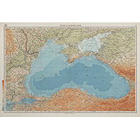
Map of the Black and Azov Seas from the Marine Atlas
1950
Russia and USSR - overview map
7400 x 10800 Views per day:
6
Accuracy:
Map of the Sea of Okhotsk from the Marine Atlas
1950
Russia and USSR - overview map
8400 x 9000 Views per day:
5
Accuracy:
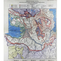
Geological map of the environs of Leningrad S.A. Yakovleva
1950
Thematic map of Leningrad region
12000 x 28200 Views per day:
4
Accuracy:
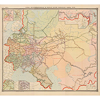
Topographic map of the environs of Dedovsk and Nakhabino
1943
-
1956
Moscow region - detailed map
17400 x 12400 Views per day:
20
Accuracy:
Map of railways of the USSR in 1950
1950
Thematic map of Russia and USSR
1200 x 1000 Views per day:
1
Accuracy:
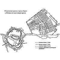
Changing the boundaries of the city of Brest from the 11th century to the present
1000
-
1950
History map
2200 x 1800 Views per day:
2
Accuracy:
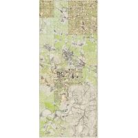
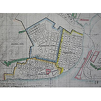
Planning project of Cherepovets 1950
1950
Map of Сherepovets
2800 x 3400 Views per day:
4
Accuracy:
Topographic map of part of the Samarskaya Luka
1950
Samara region - detailed map
NEXT