Home
All maps
History maps
Popular maps
Regional maps of Russia and countries of the former Soviet Union:
M
oscow
S
aint Petersburg
A
bakan
Anadyr
Arkhangelsk
Astrakhan
B
arnaul
Belgorod
Birobidzhan
Blagoveshchensk
Bryansk
C
heboksary
Chelyabinsk
Chita
E
lista
G
orno-Altaysk
I
rkutsk
Ivanovo
Izhevsk
K
aliningrad
Kaluga
Kazan
Kemerovo
Khabarovsk
Khanty-Mansiysk
Kirov
Kostroma
Krasnodar
Krasnoyarsk
Kurgan
Kursk
Kyzyl
L
ipetsk
M
agadan
Maykop
Murmansk
N
aryan-Mar
Nizhny Novgorod
Novosibirsk
O
msk
Orenburg
Oryol
P
enza
Perm
Petropavlovsk-Kamchatsky
Petrozavodsk
Pskov
R
ostov-on-Don
Ryazan
S
alekhard
Samara
Saransk
Saratov
Sevastopol
Simferopol
Smolensk
Stavropol
Syktyvkar
T
ambov
Tomsk
Tula
Tver
Tyumen
U
lan-Ude
Ufa
Ulyanovsk
V
eliky Novgorod
Vladimir
Vladivostok
Volgograd
Vologda
Voronezh
Y
akutsk
Yaroslavl
Yekaterinburg
Yoshkar-Ola
Yuzhno-Sakhalinsk
•
Belarus
Kazakhstan
Ukraine
Other countries
Online historical maps of Russia and the USSR
Map fragment
Map name
Year
Region
-
Map type
Preview
8200 x 7000 Views per day:
1
Accuracy:
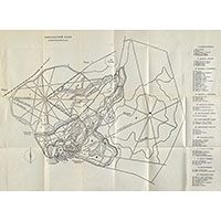
Schematic plan of Pavlovsk Park, 1954
1954
Map of Pavlovsk
4600 x 3200 Views per day:
5
Accuracy:
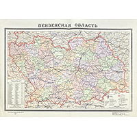
Administrative map of Penza region 1954
1954
Penza region - overview map
35200 x 13000 Views per day:
1
Accuracy:
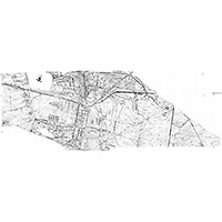
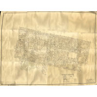
Plan of the city of Molodechno 1954. Geo survey 1:2000.
1954
Map of Molodechno
6400 x 9600 Views per day:
2
Accuracy:
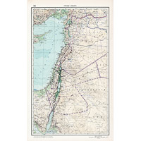
Map of the countries of the Levant from the 1954 Soviet World Atlas
1954
World - overview map
9600 x 6000 Views per day:
7
Accuracy:
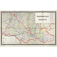
Administrative map of the Chkalovsk region 1954
1954
Orenburg region - overview map
3200 x 3600 Views per day:
4
Accuracy:
Soviet topographic map of Akmolinsk and environs
1954
Kazakhstan - detailed map
5600 x 7400 Views per day:
10
Accuracy:
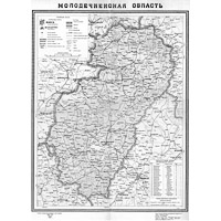
Administrative map of the Molodechno region of 1954
1954
Belarus - overview map
8000 x 7400 Views per day:
5
Accuracy:
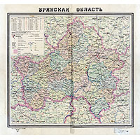
Administrative map of the Bryansk region, 1954
1954
Bryansk region - overview map
15400 x 11000 Views per day:
6
Accuracy:
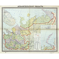
Administrative map of the Arkhangelsk region, 1954
1954
Arkhangelsk region - overview map
5200 x 6000 Views per day:
3
Accuracy:
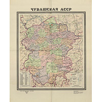
Administrative map of the Chuvash Autonomous Soviet Socialist Republic, 1954
1954
Chuvash Republic - overview map
4000 x 3000 Views per day:
6
Accuracy:
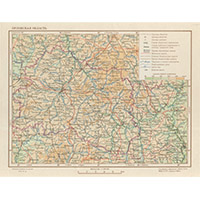
Physical map of the Oryol region in 1954
1954
Oryol region - overview map
9800 x 8400 Views per day:
5
Accuracy:
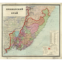
Administrative map of the Primorye territory, 1954
1954
Primorye territory - overview map
9400 x 6800 Views per day:
2
Accuracy:
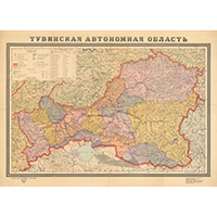
Administrative map of the Tuva autonomous region, 1954
1954
Tuva Republic - overview map
7600 x 6000 Views per day:
4
Accuracy:
Plan of the central part of Belgorod, 1954
1954
Belgorod - city plan
16200 x 11000 Views per day:
3
Accuracy:
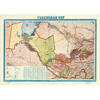
Administrative map of the Uzbek SSR 1954
1954
World - overview map
NEXT