Home
All maps
History maps
Popular maps
Regional maps of Russia and countries of the former Soviet Union:
M
oscow
S
aint Petersburg
A
bakan
Anadyr
Arkhangelsk
Astrakhan
B
arnaul
Belgorod
Birobidzhan
Blagoveshchensk
Bryansk
C
heboksary
Chelyabinsk
Chita
E
lista
G
orno-Altaysk
I
rkutsk
Ivanovo
Izhevsk
K
aliningrad
Kaluga
Kazan
Kemerovo
Khabarovsk
Khanty-Mansiysk
Kirov
Kostroma
Krasnodar
Krasnoyarsk
Kurgan
Kursk
Kyzyl
L
ipetsk
M
agadan
Maykop
Murmansk
N
aryan-Mar
Nizhny Novgorod
Novosibirsk
O
msk
Orenburg
Oryol
P
enza
Perm
Petropavlovsk-Kamchatsky
Petrozavodsk
Pskov
R
ostov-on-Don
Ryazan
S
alekhard
Samara
Saransk
Saratov
Sevastopol
Simferopol
Smolensk
Stavropol
Syktyvkar
T
ambov
Tomsk
Tula
Tver
Tyumen
U
lan-Ude
Ufa
Ulyanovsk
V
eliky Novgorod
Vladimir
Vladivostok
Volgograd
Vologda
Voronezh
Y
akutsk
Yaroslavl
Yekaterinburg
Yoshkar-Ola
Yuzhno-Sakhalinsk
•
Belarus
Kazakhstan
Ukraine
Other countries
Online historical maps of Russia and the USSR
Map fragment
Map name
Year
Region
-
Map type
Preview
28400 x 23200 Views per day:
40
Accuracy:
Satellite image of Moscow 1968
1968
Moscow - city plan
29200 x 31800 Views per day:
5
Accuracy:
Satellite image of Belogorsk and Its suburbs, 1968
1968
Crimea - detailed map
11000 x 15000 Views per day:
2
Accuracy:
Satellite image of Sudak and Its suburbs, 1968
1968
Crimea - detailed map
17000 x 29000 Views per day:
3
Accuracy:
Satellite image of Feodosia and its suburbs 1968
1968
Crimea - detailed map
10000 x 14200 Views per day:
2
Accuracy:
Satellite image of Koktebel (Planersky) and its suburbs 1968
1968
Crimea - detailed map
21000 x 15600 Views per day:
4
Accuracy:
Satellite image of Stary Krym and its suburbs 1968
1968
Crimea - detailed map
48000 x 24000 Views per day:
5
Accuracy:
Satellite image of of the south of the Kerch Peninsula, 1968
1968
Crimea - detailed map
7000 x 6000 Views per day:
1
Accuracy:
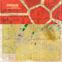
Kharkov city transport routes in 1968
1968
City plan
4600 x 4400 Views per day:
8
Accuracy:
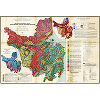
Hydrogeological map of the Khabarovsk Territory and the Amur Region
1968
Thematic map of Khabarovsk territory
41600 x 15600 Views per day:
2
Accuracy:
Satellite image of Nazran and Its suburbs, 1968
1968
Map of Nazran
30800 x 15800 Views per day:
3
Accuracy:
Satellite image of Gorno-Altaysk and Its suburbs, 1968
1968
Gorno-Altaysk - city plan
18200 x 9400 Views per day:
10
Accuracy:
Satellite image of Vladimir and Its suburbs, 1968
1968
Vladimir - city plan
3800 x 4400 Views per day:
10
Accuracy:
Administrative map of the Kirov region, 1968
1968
Kirov region - overview map
44600 x 30400 Views per day:
30
Accuracy:
Satellite image of Samarskaya Luka, Tolyatti and Syzran, 1968
1968
Samara region - detailed map
2800 x 2200 Views per day:
2
Accuracy:
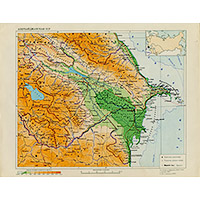
Map of the Azerbaijan SSR. Great Soviet Encyclopedia.
1968
World - overview map
NEXT