Home
All maps
History maps
Popular maps
Regional maps of Russia and countries of the former Soviet Union:
M
oscow
S
aint Petersburg
A
bakan
Anadyr
Arkhangelsk
Astrakhan
B
arnaul
Belgorod
Birobidzhan
Blagoveshchensk
Bryansk
C
heboksary
Chelyabinsk
Chita
E
lista
G
orno-Altaysk
I
rkutsk
Ivanovo
Izhevsk
K
aliningrad
Kaluga
Kazan
Kemerovo
Khabarovsk
Khanty-Mansiysk
Kirov
Kostroma
Krasnodar
Krasnoyarsk
Kurgan
Kursk
Kyzyl
L
ipetsk
M
agadan
Maykop
Murmansk
N
aryan-Mar
Nizhny Novgorod
Novosibirsk
O
msk
Orenburg
Oryol
P
enza
Perm
Petropavlovsk-Kamchatsky
Petrozavodsk
Pskov
R
ostov-on-Don
Ryazan
S
alekhard
Samara
Saransk
Saratov
Sevastopol
Simferopol
Smolensk
Stavropol
Syktyvkar
T
ambov
Tomsk
Tula
Tver
Tyumen
U
lan-Ude
Ufa
Ulyanovsk
V
eliky Novgorod
Vladimir
Vladivostok
Volgograd
Vologda
Voronezh
Y
akutsk
Yaroslavl
Yekaterinburg
Yoshkar-Ola
Yuzhno-Sakhalinsk
•
Belarus
Kazakhstan
Ukraine
Other countries
SORT BY:
New Arrivals
Oldest to Newest
Newest to Oldest
Most Popular
MAP TYPE:
All
City plans
Detailed
Overview
Thematic
History
Popular
Historical maps of Russia and the USSR
Map fragment
Map name
Year
Region
-
Map type
Preview
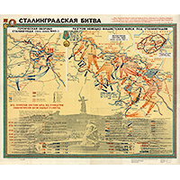
2600 x 2200 Views per day:
20
Accuracy:
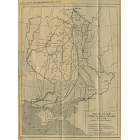
Map of the Battle of Stalingrad in November - December 1942
1942
History map
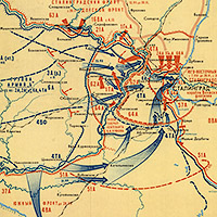
2000 x 2200 Views per day:
8
Accuracy:
Scheme of the defense of Stalingrad from July to November 1942
1942
History map
4000 x 2600 Views per day:
40
Accuracy:
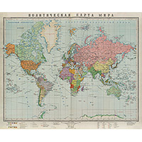
Political map of the world in 1928
1928
History map
8000 x 6400 Views per day:
110
Accuracy:
Political map of the world in 1945
1945
History map
16200 x 12800 Views per day:
40
Accuracy:
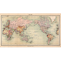
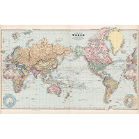
Map of the World 1904 by Edward Stanford
1904
History map
4400 x 5000 Views per day:
1
Accuracy:
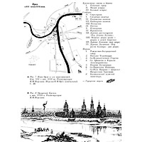
Oryol in the 16th - early 17th centuries
1600
History map
29400 x 25400 Views per day:
80
Accuracy:
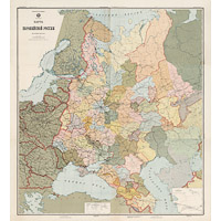
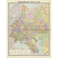
Administrative map of the European part of the USSR in 1923
1923
History map
1200 x 1000 Views per day:
1
Accuracy:
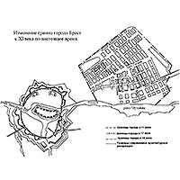
Changing the boundaries of the city of Brest from the 11th century to the present
1000
-
1950
History map
14200 x 13800 Views per day:
140
Accuracy:
Administrative map of the European part of the USSR, 1976
1976
History map
2200 x 1800 Views per day:
4
Accuracy:
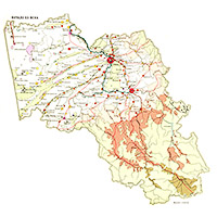
Map of Altai at the beginning of the 20th century
1916
History map
5400 x 7600 Views per day:
7
Accuracy:
Novgorod pyatins at the end of the 15th - beginning of the 16th century
1510
History map
3600 x 2600 Views per day:
5
Accuracy:
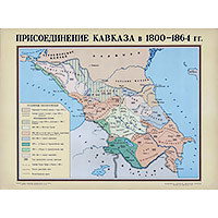
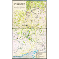
Annexed territories of the Caucasus from 1800 to 1860
1860
History map
6000 x 5200 Views per day:
30
Accuracy:
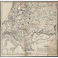
Map of the Slavic countries of the 10th century
950
History map
4400 x 6400 Views per day:
10
Accuracy:
Reconstruction of the Big Drawing
1556
-
1627
History map
3600 x 4000 Views per day:
10
Accuracy:
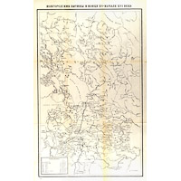
Map of routes between Moscow and Crimea in the 16th and 17th centuries
1480
-
1620
History map
BACK
NEXT
1
2
3
4
5
6
7
>>>